A good relay should have:
- Line of sight back to your fibre or another relay – You will probably feed the relay site with a wireless backhaul, so you’ll need line of sight to something.
- Line of sight to your customers – In most cases you will want to be able to see several hundred rooftops from a relay to make sure it will be viable.
- Easy access to Power – This is easy to overlook when you’re getting started. Make sure you have a place to plug in your equipment. Rooftops often do not have AC Power outlets. Also structures like telephone poles and water tanks often do not have easy access to AC power. Backup battery power will also probably be needed. Possible use of solar power is becoming more popular
- A place to mount your equipment – Make sure you can attach your equipment to the structure somehow.
- 24/7 access for maintenance – If a device at the site fails you will need to get there in a hurry to replace it or risk losing customers. If possible push to have your own copy of any keys and any necessary key codes to get to your equipment quickly any time.
How to identify potential relays
1. Drive around the streets in the area
Scan the horizon for buildings or other structures that are visible from the street. These could make good candidates for relay sites. If possible physically visit these locations. Can you see lots of rooftops from those places?
Also note the height of the trees – are most houses surrounded by trees, and are the trees taller than the houses? If so that will be a problem.
2. Use a drone to survey the landscape from roof level
Go to a park or another open area and fly a drone with an attached camera to roughly the height of the rooftops and spin it around. Review your video footage and see if there are any potential relay sites visible above the trees.
3. Use Google Earth
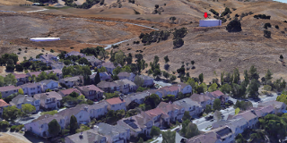
Make sure you’re using Google Earth Pro . If you’re lucky the area you’ve chosen will have high resolution topographic data available like this:

Even if you don’t have that high-res data you can still get a good idea about trees, foliage and buildings by looking at the satellite view. Zoom in close to the rooftops of the areas you’re trying to cover and then pan around and look at the horizon. Anything that pops up over the horizon might make a good relay site candidate.

Watertank on the hill marked with a red arrow
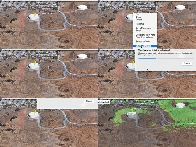
Identify a few of those and then run a viewshed from each location. The viewshed will highlight parts of the map that are visible from a certain location, giving you effectively a map of what has line of sight to the Relay Site. To run a viewshed:
- Drop a placemarker
- Right click the marker and select ‘Show Viewshed’ <– this is only available in Google Earth Pro
- You might get a pop-up asking to move the height of the marker, just click ‘Adjust Automatically’

Same watertank from the last image